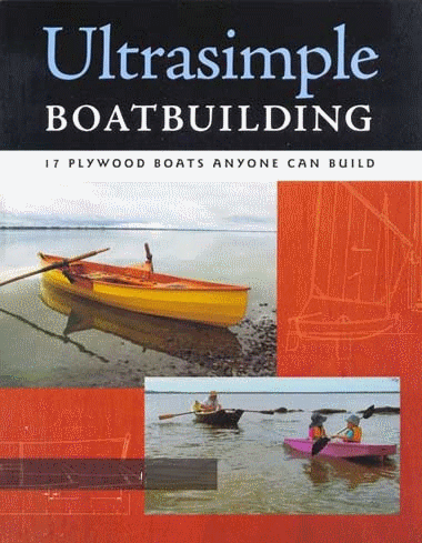
Boat Plans Stitch And Glue
It smelled like old Wendys fast food that lay smoldering under a Las Vegas highway overpass, somewhat wicked but rapidly desiccating into something oddly familiar and satisfying. Much like a flatulence that waffles between pride and disownership. The desert dries all things with a hint of sage and concrete, as does the mystery powder in the bottom of the Doodie Bag (but without the sage).
I was contemplating this and other mysteries from the toilet lid of a 5 gallon bucket amongst pine needles and the quiet lapping of water on a Maine island. The flies were already moving onto my location and unbeknownst to me and my buzzing friends, so were 10 college women (and some men) intent on preparing a campsite for a Freshman Orientation Week.
This can only mean one thing...
Sea Pearl SCOUT IS BACK OUT ON THE PROWL!
 |
| ROAAWWRR |
AHOY INTREPID READERS!
I welcome you back to another wonderful and beguiling installment of GISAmateur Style! This has been a tumultuous year of tribulation, complete with physical ailments, professional shakeups, ponderous tragedy, and mighty little sailing. (We missed the Small Reach Regatta, horrors!). Last week however, SCOUT and I went cruising, and we did it in company and we did it well and BY POSEIDON and his graciousness and his fury we had a goddamm good time and some great sailing!
-Commodore Hazard! and his lovely sneaky fast Coquina SLIFPER
-GreenMountain John and his one-and-only lug rigged yawl Ilur in the world, WAXWING
-Capn Jon, of Pheonix III fame but in his newly acquired SeaPearl 21, INDIGO
-And me, Captain Callsign, with of course, SCOUT.
Our objective was the circumnavigation of Sebascodegan Island, or Great Island, which I did solo last year. You can read this account here. We decided to do it again because it is just such a groovy trip, with varied sailing, nice little holes to duck into, and it was in good proximity to the four of us and our schedules.
DAY 1
 |
For better viewing: http://www.charts.noaa.gov/OnLineViewer/13290.shtml |
SCOUT and I were the last to arrive at Bethel Point Marine, which has parking and a slimey ramp. Overnight trailer parking can be tough to find, and Bethel Point offers it at $6 a day per vehicle. Dont screw this up! Everyone was already in the water, sprawling around their boats and looking suspiciously content. Commodore Hazard came bouncing up the ramp and greeted me to watch SCOUT while I parked the trailer. We had little sunlight left and in a jumble of camping gear and badly stowed rigging, we set forth for our first anchorage of the night, tucked in just west of Yarmouth Island.
 |
| Capn Jon took this picture click for more |
 |
| Commodore Hazard and SLIFPER Capn Jon took this picture click for more |
I awoke way too early in the morning with Commodore Hazard and GreenMountain John shouting at each other across the anchorage about what a "GREAT DAY" it was. It was 6am. Maybe 5. It was early. I dont know. Some people work for a living.
We rafted up for breakfast, and planned to go around Orr before heading up the west coast of Sebascodegan.
DAY 2: THE EPIC RUN
 |
| Red arrow lower left: Lunch Red arrow upper right: 2nd Anchorage Yellow: Rowing Tacking is approximate |
 |
| Commodore Hazard was ready to go about an hour before anyone else. If this is Retirement, I want some. |
 |
| No one else is ready. |
We put in at Cedar Beach on the northern tip of Bailey Island to break down the rigs to get under the the bridge between Bailey and Orr Island. Cedar Beach is a touchpoint on public access to water. I have said this before and I will say it again... access to the water is part of our American Birthright, and we let it slip away to private interests at our peril!
 |
| HISTORIC first picture of SCOUT and INDIGO together! Capn Jon celebrates in the background! |
 |
| SCOUT and I rowing underneath the bridge. It looks like a bunch of jumbled concrete, right? Capn Jon took this picture, click for more |
 |
| NO its lincoln-log stacked blocks of granite! This didnt take any work, Im sure. More here |
After lunch, we spun out and then began one of the most incredible downwind runs I have ever had the pleasure to enjoy. The tide and the wind were at our backs, the breeze was building, we were four well matched boats, and the sun was out and we were going somewhere!
 |
| Small boat friendly beach! |
 |
| WAXWING |
 |
| A Rozinante... it was a real treat to watch Commodore Hazard and SLIFPER spin around her. |
 |
| Hazard plays around with just the Main, and scoots along just fine. |
 |
| WAXWING, SLIFPER, and INDIGO coming out from under the Mountain Rd. bridge and into the Ewin Narrows. |
 |
| Shipshape, honest. |
 |
| INDIGO rounding the corner at Doughty Point with the Long Reach in the background. GREAT SAILING |
 |
| INDIGO |
 |
| Capn Jon doesnt just sail He slums it. |


 |
| Wing and wing down the Ewin Narrows |
 |
| Capn Jon took this picture |
 |
| Capn Jon took this picture, too! |
 |
| Striking the rig down at Gurnet Straight. |
GreenMountain John decided to rig an outhaul, which as my Intrepid Readers will remember, is usually some sort of exercise in frustration, and this was no exception. I swore at this moment that I am finally going to get around to getting that Anchor Buddy, which would solve a lot (not all) of our shore/tide problems. That being said, theres something humorous about watching two sailors tangle with outhauls.
 |
| SLIFPER awash in green |
 |
| Something is rotten in the state of Outhaul. Commodore Hazard attempts to rectify the issue. |
 |
| Now the outhaul is hopelessly wrapped around SLIFPERs rudder. |
 |
| Still working on it. That Commodore Hazard is persistent, he is. Hey...Whos outhaul is this, anyway? |
 |
| I was forced -against my will- to take this picture of the final successful outhaul attempt. This success came at a great cost of time, took two people, two boats, and much editorializing from the Peanut Gallery (me). I salute GreenMountain John for his fortitude and persistence in seeing this through. They do work sweet, when they work. |
 |
| FINALLY we can get down to eating! Most bad-ass raft up ever. |
 |
| Chef BoyardJohn just slayed this dinner for us unthankful compatriots: Spirali and pesto sauce with smoked scallops. Paired with his home-brewed beers. Luxury. |
 |
| Cured meats and soft cheeses. Commodore Hazard enlightening us on the subject of boom crutches and Other Exciting Subjects. Capn Jon listens politely to his superiors. (Smart, Capn Jon!) |
DAY THREE

So it came to pass that we awoke to a more humid and less sunny day than Day 2. We decided on a humble goal of making it down to the The Basin and tucking in there for the afternoon. We would have the tide and wind slightly against us, and we just went ahead and enjoyed the sailing it would provide.
Of course this morning after my coffee I headed onto Merritt Island to enjoy my morning constitutional. It was foggy and midweek and who would show up at 8am?, I thought to myself. I dawdled and certainly did not conceal myself, planting my 5 gallon pail right on a major walking thoroughfare from the north end to the south end of the island. I was a king, and this was my land, dammit! I leisurely finished up and turned around just to see a group of college girls (and 2 dudes or so) come walking over the landbridge from the mainland! Forty seconds later, and they would have received what I would imagine is a very unpleasant site of me with my pants bunched around my seaboots cleaning up. My timing was as close as close could be. I walked by the happy group, Doodie Bag in hand, while they cavorted over to the island where moments ago I was most vulnerable. Im almost regretting my great timing, I feel I robbed them of a good story to tell over the weekend to their classmates. Maybe I would have said something pithy too, just to spice up their story. (probably not)
Sailing wise, at times the wind was fickle coming through the narrows, but it picked up just fine later in the day and we made good time. We stopped for lunch for more cured meats and soft cheeses, of course. INDIGO and SCOUT had an epic tacking battle into The Basin that wowed the locals who motored over later to talk to us champion sailor types. Then we settled in for another evening of eating. I think at this point we were beginning to feel it.
 |
| Waking up on Day 2 was a little more peaceful, less shouting and the like. |
 |
| "Hey! You kids! Get off my lawn!" |

 |
| GreenMountain John sculling WAXWING and showing us all how its done. In the background you can see Commodore Hazard preparing for his morning constitutional, after the college group had left, of course. He either has better timing, or less sense of adventure. Not sure which is better. |

 |
| Lunch time! Yeah! This is where the immortal "Captain F***Head" (as christened by the Commodore) motored by with a big wake bashing the Coquinas rudder onto the rocks, forever turning "Slipper" into "Slifper" as the pintle rubbed the paint off the transom. ...And if you think about it, SLIFPER is just so much cooler, because now theres a story. |
 |
| Tied up in The Basin in triumph. This is what it looks likes, when one triumphs at life. |
 |
| This is what not-so triumphant puzzlement looks like. How do I get off the rock and into the boat without doing what I did last year to myself? |
 |
| Making the dinner, again! Tonight, it was Capn Jons turn. He added a special fiberglass ingredient to his dish after he dumped dinner into his bilges. This does not bother sailors like us, this only makes us more resilient! Delicious boaty taste, hmm hmm good. |

Do you find information about Boat Plans Stitch And Glue are you looking for? If not, below may help you find more information about the Boat Plans Stitch And Glue. Thank you for visiting, have a great day.
Pontoon Boat Plans | Finisterra is For Sale
| 0 komentar |Label: alaska, Boat Plans, cruise, finisterra, for, is, sale
Pontoon Boat Plans
All good things come to an end eventually and after three and a half years, 18,000 miles and a zillion wonderful moments aboard Finisterra, the time has come for us to turn the page and start another chapter. So we are reluctantly putting Finisterra up for sale.
Finisterra has been the perfect cruising boat for us. Shes been tough, reliable and extremely comfortable to cruise aboard and we are going to miss her. Ive created a web site that describes the boat and equipment so if youd like to know more about her, visit her web site at finisterraspecifications.blogspot.com
 |
| Finisterra on a mooring in Catalina at the end of our last voyage to Mexico. |
Finisterra has been the perfect cruising boat for us. Shes been tough, reliable and extremely comfortable to cruise aboard and we are going to miss her. Ive created a web site that describes the boat and equipment so if youd like to know more about her, visit her web site at finisterraspecifications.blogspot.com

Do you find information about Pontoon Boat Plans are you looking for? If not, below may help you find more information about the Pontoon Boat Plans. Thank you for visiting, have a great day.
Yacht Boat Plans | Alaska Cruise
| 0 komentar |Label: 37, alaska, Boat Plans, cruise, review, varianta
Yacht Boat Plans
Weve been home a couple of months and the time has flown by. It took a couple of weeks to get settled back in Costa Mesa. During that time we had to contend with the the passing of Woody, our English Setter. It was a sad time around the house, but he lived to the ripe old age of 14 and certainly enjoyed a pretty good life.
As soon as that little ordeal was over we took a road trip to Vancouver, BC where we met up with friends for a cruise to Alaska aboard the MS Noordam. But before we boarded the ship, we spent a couple of days touring the city. One of the highlights of our tour was hiking up Grouse Mountain. The hike is known as the Grouse Grind, 2,800 feet of vertical ascent in about 1.8 miles. There are actually two ways to do the grind. The first and most commonly used route is the staircase, which consists of 2,830 stairs. It sounded kind of boring to us so we chose the secondary route, a trail through the forest. Both routes are unrelentingly steep climbs but you are rewarded with beautiful views of the city at the summit. For more information visit www.grousemountain.com/grousegrind.
After hiking the Grind we made a side trip to the Capilano Suspension bridge.
We boarded the Noordam on Saturday morning, September 12th at the cruise ship terminal in downtown Vancouver.
The Noordam was built in Italy and christened in 2006. Here are some dimensions:
LOA: 936 feet
Beam: 105.8 feet
Gross tonnage: 82,500 tons
Power: 84,000 horsepower
Passenger decks: 11
Capacity: 1,916 passengers and 800 crew
The ship is powered by a CODAG-Electric (Combined Diesel and Gas) system of diesel and gas turbine powered generators that drive Azipods instead of conventional propellers.
The diesel and gas turbine engines dont actually turn the propellers through shafts like a conventional boat, but drive large generators that supply power to the enormous electric motors encased in the Azipods. Pretty cool stuff.
 |
| Woody 2001-2014 |
 |
| The weather was a bit hazy but the views from the top of Grouse Mountain were spectacular. |
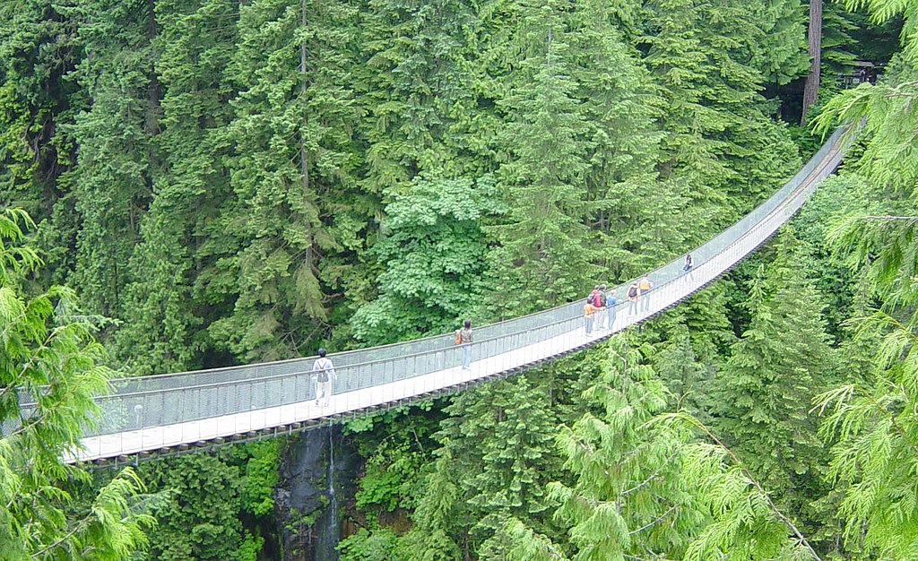 |
| Capilano Suspension Bridge is 450 feet long. It spans a river of the same name, some 220 feet below. Its privately owned and is the gateway to several nature trails on the far side. Photo courtesy of Wikipedia. |
We boarded the Noordam on Saturday morning, September 12th at the cruise ship terminal in downtown Vancouver.
 |
| The Noordam |
LOA: 936 feet
Beam: 105.8 feet
Gross tonnage: 82,500 tons
Power: 84,000 horsepower
Passenger decks: 11
Capacity: 1,916 passengers and 800 crew
The ship is powered by a CODAG-Electric (Combined Diesel and Gas) system of diesel and gas turbine powered generators that drive Azipods instead of conventional propellers.
 |
| An Azipod consists of a propeller and electric motor unit installed where a conventional propeller and rudder would be on the ship. "Azipod" is a trademarked name for ABB Groups version of this type of propulsion system. The Noordam is equipped with twin Azipods. Photo courtesy of Wikipedia. |
After boarding the vessel and settling into our stateroom on deck 4, we went through a lifeboat drill while the crew cast off the dock lines and the Noordam puttered out into the channel. The stateroom was quite spacious, with a king size bed, sofa, shower/tub in the head and, best of all, the wall facing outboard was all glass, giving an excellent ocean view. Actually it was an excellent view of the 40 foot motorized lifeboat that was stowed just outside the glass, but we still had a pretty fair ocean view. Our first destination would be Juneau, Alaska, which we would reach on Monday around noon. To get there we transited most of the Inside Passage, which stretches from Washington state to Skagway.
The Noordam headed northwest, passing under the beautiful Lions Gate Bridge and entered the Strait of Georgia, doing about 20 knots in fairly calm and balmy conditions. The Strait separates Vancouver Island from the mainland. It is about 150 miles long and varies between 11 and 34 miles wide. That sounds pretty spacious but it is actually full of islands and narrow channels, especially in the northern part of the strait. I was told that the Noordams crew includes three navigators, so the vessel trundled along at 18-20 knots night and day through the narrow parts as well as the wide parts of the channel.
The scenery in the Strait is beautiful. Evergreen forests cover the rugged terrain and surround the occasional small towns and villages on both sides of the channel. Whales were plentiful in this region and we saw orcas and what appeared to be humpbacks from the observation deck as well as from our stateroom.
In the early hours of the next morning the Noordam passed into Discovery Passage, which is a narrow channel that connects the Strait of Georgia to Johnstone Strait by way of Seymour Narrows.
The Narrows is an interesting place for big ships, or small ones, because its about 3 miles long and averages about 750 yards wide. It is a place with strong currents, sometimes up to 15 knots.
Unfortunately it was quite dark when we passed through the Narrows and I really couldnt see much of it. Back in the 1790s when Captain George Vancouver was exploring this region he is reputed to have described the narrows as "One of the vilest stretches of water in the world." There used to be a serious navigational hazard near the south end of the Narrows called Ripple Rock, which consisted of two submerged peaks rising to a depth of about nine feet below the surface. These rocks had quite a career, sinking 119 vessels between 1875 and the 1950s. By 1956 the government had seen enough of the Rock, so they spent over two years tunneling into it and packing it with 1,375 tons of high explosives. On April 5th, 1958 they blew it up. At that time it was the largest intentional, non-nuclear blast in North America.
The Noordam transited the narrows without mishap, and passed into the Johnstone Strait and then the Queen Charlotte strait, which carried us to the northern end of Vancouver Island and into Queen Charlotte Sound. The Sound is roughly 100 nautical miles long and is exposed to the Pacific Ocean, so the Noordam rolled just barely enough to feel it for about five hours. Then we were in the Hecate Strait which runs about 140 miles northwestward to Dixon Entrance. It averages about 45 miles wide and we seemed to be going right up the middle of it so there was little to see. The Noordam passed from Canadian to US territorial waters at the northwest end of Dixon Entrance.
We headed out toward the open sea from the Entrance and reentered protected waters at the southern tip of Baranof Island. From there it was another 150 nautical miles to Juneau by way of Frederick Sound and Stephens Passage. The Noordam tied up to the dock around noon and shortly after that we went ashore.
Juneau is the capital of Alaska and boasts a population of around 33,000 people. It is located on the mainland coast of Alaska but the surrounding terrain is so rugged that no roads have been built to the rest of the state, so the city must be supplied by boat or air. Most residents of Juneau work for the government, but there are lots of locals working in the tourist trade and fishing industries as well.
Instead of signing up with an expensive tour company our group of six hiked into town from the terminal and found a taxi driver that would take us out to see the Mendenhall Glacier and falls.
By dusk we were back aboard the Noordam. Dinner aboard the ship was always a fun time. Our group, Wolf and Judy, Vic and Susan, and us always shared a table and usually had a pre-party in one of our staterooms. The food was consistently very good and we had each brought a couple of bottles of wine in our luggage, so the drinks were quite good as well.
The Noordam cast off at 2200 hrs. that night, bound for Skagway. It was a cold and overcast night and I was glad to be aboard a large and well heated ship instead of the Finisterra. The ship arrived around 0600 the next morning and we went ashore just after breakfast and boarded the narrow gauge White Pass/Yukon train. Its basically a tourist train that takes you directly from the dock to White Pass, which lies at an elevation of 2,865 feet. I couldnt help comparing it to El Chepe, the train that took us up to Copper Canyon in Mexico. The main difference is that there is no bar car on this train. We all agreed that it could use one. Aside from that, it was a pleasant ride up to the pass and the narrator who talked constantly over the loudspeaker was only a little bit annoying. The train was full of tourists snapping pictures of the passing scenery. Somehow it made me not want to take any photos myself.
The town of Skagway isnt much. It has a year round population of around a thousand souls, which doubles during the tourist season. It was founded in 1887 by one Billy Moore, who thought it would be a good jumping-off place for miners seeking gold. Sure enough, gold was discovered in the Klondike region of the Yukon Territory and miners flooded into Skagway. By 1898 the town had swelled to a population of around 9,000 and was the largest city in Alaska. That lasted a couple of years and by the turn of the century Skagways economy collapsed.
Nowadays tourism is the primary driver of the towns economy, with about a million tourists per year arriving, mostly by cruise ship. The few streets in town are lined with tourist shops, a few bars and restaurants, and not much else. We reboarded the ship in the afternoon, having seen pretty much all there was to see in Skagway. The dress code for dinner that evening was coats and ties for the men and dresses for the ladies. I hadnt worn a tie since I retired a couple of years ago, but the formal attire did not detract from the excellent steak and lobster that was served so I didnt grumble too much about it, and the women all looked beautiful as well.
The Noordam sailed for Glacier Bay while we were enjoying dinner. At dawn the next morning the ship came to a stop at the head of the bay and, using its rotatable Azipods and 7,500 horsepower bow thrusters, executed a 360 degree turn in place, so the passengers could all get a good look at the glaciers and sea life there. Earlier a ranger from Glacier Bay National Park had boarded the ship and she described the wonders of the region over the loudspeakers as the boat rotated. The bay is populated by fifteen glaciers, including Margerie, Grand Pacific, Johns Hopkins, and McBride.
The Noordam stayed in Glacier Bay until about 1800 hrs, then headed southeast toward Ketchikan, arriving at 1000 the following morning. Wed heard that there were lots of bears here and the shipboard tour company as well as a dozen or so tour operators on the dock were most anxious for us to see them. They were shouting at the tourists as we came off the ship offering special prices and guaranteeing that wed see bears and eagles up close and personal for only a hundred dollars per person. They all seemed disappointed in us because we failed to take advantage of their offers.
Instead, we wandered down the street and found a taxi van whose driver who looked like he was doing nothing but texting on his I-phone, so I approached him and we struck a deal. For $140 bucks hed take us to Herring Cove, where the bears go to catch salmon and pose for the tourists. He turned out to be an amiable sort and spent three hours with us while we lingered at the cove watching the occasional bear emerge from the forest a couple of hundred yards away. The best part of the excursion was hearing his stories of his life in Ketchikan. After an hour or so, the place started filling up with tourists so our driver took us back to town, stopping to show us various points of interest, which were not many, along the way. It was a pretty good tour at a bargain price.
Ketchikan is fairly cosmopolitan compared to Skagway, with a population of over 8,000. Many Ketchikanians fly south for the winter, but our driver stays on. He said its much more peaceful after the hubbub of the tourist season dies down. I believe him.
We sailed from Ketchikan around 1800 hrs. bound for Vancouver. The weather forecast was for strong southerly winds and the ship veered away from a direct course and we sailed through a labyrinth of narrow channels instead of bucking bigger seas in Queen Charlotte Sound. The Noordam arrived in Vancouver at 0700 Saturday morning and we were back at Wolf and Judys home by noon where we played Mexican Train all afternoon.
The next day we visited friends Howard and Lynn at their flat on the 33rd floor of the Shaw building in downtown Vancouver. The views from their balcony were breathtaking. By mid-afternoon on Sunday we were back on the road, headed south. I wanted to get past Seattle to avoid the traffic gridlock that usually plagues the I-5 freeway between Lynnwood and Tacoma on weekdays, so we didnt stop until we got to Olympia.
We got back on the road around 10:00 the next morning and headed south at a leisurely pace. The plan was to check out a few wineries between Portland and Corvallis in the early part of the day, then visit Lisas alma mater, Oregon State University. With football season in full swing she needed a new flag and some flannel pajama bottoms with the OS logo on them. Shes still an avid fan of the fighting Beavers. Unfortunately, they arent doing too well this year, with a 2-2 record. She has high hopes for the upcoming game against Arizona though.
We wanted to visit Crater Lake on this trip so from Corvallis we drove to Roseburg, where we spent the night. We had an excellent dinner at Dinos Italian Ristorante and chatted with our waitress who was a student at Umpqua Community College. As we drove back to our hotel we remarked on what a sweet small town Roseburg is, unaware of the tragedy awaiting the people here. Our hearts are grieving for them. Its obvious that no amount of senseless carnage is going to change the minds of people who treasure their guns and would rather continue on the path of killing than adopt reasonable gun laws. Its a uniquely American malady that we will probably only cure when we discover a cure for stupidity.
We turned off of I-5 in Roseburg and drove for miles along the beautiful Umpqua river. We stopped occasionally to wander along the banks of the river, where we spotted the occasional fisherman standing on a rock in midstream, fly rod in hand. Idyllic scenes. We arrived at Crater Lake a little before noon and spent the afternoon hiking and enjoying this pristine natural wonder.
The lake was created when a volcano named Mt. Mazama collapsed in on itself around 7,700 years ago, creating a caldera or bowl over 4,000 feet deep in the middle where the peak used to be. Over time, rain and snowmelt filled the bowl, creating the lake. No rivers or streams flow into the lake so its only source of water is rain and snow. Over the next several hundred years there were more eruptions within the caldera, creating several cinder cones, one of which eventually rose out of the water and became Wizard Island.
We got back on the road in the late afternoon and continued south, spending a night in Redding, California before heading up into the Sierras to visit family in Nevada City. Its always fun to hang out with Brian and Karen at their beautiful home nestled in the hills above the town. We stayed long enough to spend a day soaking up sunshine as we floated on tubes in the Yuba River, then got back on the road.
We drove south to Paso Robles where we spent the night and did some wine tasting in the surrounding area, and picked up some wine that had been waiting for us since last November. From there we headed home, arriving around 9:00pm, all safe and sound.
 |
| DowntownVancouver viewed from the stern of the Noordam. The cruise ship terminal is the white structure on the left. |
 |
| Lions Gate Bridge, viewed from the bow of the Noordam. |
The Noordam headed northwest, passing under the beautiful Lions Gate Bridge and entered the Strait of Georgia, doing about 20 knots in fairly calm and balmy conditions. The Strait separates Vancouver Island from the mainland. It is about 150 miles long and varies between 11 and 34 miles wide. That sounds pretty spacious but it is actually full of islands and narrow channels, especially in the northern part of the strait. I was told that the Noordams crew includes three navigators, so the vessel trundled along at 18-20 knots night and day through the narrow parts as well as the wide parts of the channel.
The scenery in the Strait is beautiful. Evergreen forests cover the rugged terrain and surround the occasional small towns and villages on both sides of the channel. Whales were plentiful in this region and we saw orcas and what appeared to be humpbacks from the observation deck as well as from our stateroom.
 |
| Lighthouse near Vancouver. |
In the early hours of the next morning the Noordam passed into Discovery Passage, which is a narrow channel that connects the Strait of Georgia to Johnstone Strait by way of Seymour Narrows.
The Narrows is an interesting place for big ships, or small ones, because its about 3 miles long and averages about 750 yards wide. It is a place with strong currents, sometimes up to 15 knots.
 |
| Seymour Narrows with a rough approximation of the Noordams course. |
The Noordam transited the narrows without mishap, and passed into the Johnstone Strait and then the Queen Charlotte strait, which carried us to the northern end of Vancouver Island and into Queen Charlotte Sound. The Sound is roughly 100 nautical miles long and is exposed to the Pacific Ocean, so the Noordam rolled just barely enough to feel it for about five hours. Then we were in the Hecate Strait which runs about 140 miles northwestward to Dixon Entrance. It averages about 45 miles wide and we seemed to be going right up the middle of it so there was little to see. The Noordam passed from Canadian to US territorial waters at the northwest end of Dixon Entrance.
We headed out toward the open sea from the Entrance and reentered protected waters at the southern tip of Baranof Island. From there it was another 150 nautical miles to Juneau by way of Frederick Sound and Stephens Passage. The Noordam tied up to the dock around noon and shortly after that we went ashore.
Juneau is the capital of Alaska and boasts a population of around 33,000 people. It is located on the mainland coast of Alaska but the surrounding terrain is so rugged that no roads have been built to the rest of the state, so the city must be supplied by boat or air. Most residents of Juneau work for the government, but there are lots of locals working in the tourist trade and fishing industries as well.
Instead of signing up with an expensive tour company our group of six hiked into town from the terminal and found a taxi driver that would take us out to see the Mendenhall Glacier and falls.
 |
| It was drizzling rain most of the time we were at Mendenhall, but the grandeur of the glacier was impressive anyway. In 1958 the glacier came right up to the trees in the foreground. Since then it has receded 1.75 miles, creating Lake Mendenhall. |
 |
| Growlers on Lake Mendenhall. It was here that I learned that a growler is a tiny iceberg that rises no more than 3 feet out of the water. A bergy bit is larger, rising 3 to 13 feet out of the water. |
 |
| Mendenhall Falls. |
The Noordam cast off at 2200 hrs. that night, bound for Skagway. It was a cold and overcast night and I was glad to be aboard a large and well heated ship instead of the Finisterra. The ship arrived around 0600 the next morning and we went ashore just after breakfast and boarded the narrow gauge White Pass/Yukon train. Its basically a tourist train that takes you directly from the dock to White Pass, which lies at an elevation of 2,865 feet. I couldnt help comparing it to El Chepe, the train that took us up to Copper Canyon in Mexico. The main difference is that there is no bar car on this train. We all agreed that it could use one. Aside from that, it was a pleasant ride up to the pass and the narrator who talked constantly over the loudspeaker was only a little bit annoying. The train was full of tourists snapping pictures of the passing scenery. Somehow it made me not want to take any photos myself.
The town of Skagway isnt much. It has a year round population of around a thousand souls, which doubles during the tourist season. It was founded in 1887 by one Billy Moore, who thought it would be a good jumping-off place for miners seeking gold. Sure enough, gold was discovered in the Klondike region of the Yukon Territory and miners flooded into Skagway. By 1898 the town had swelled to a population of around 9,000 and was the largest city in Alaska. That lasted a couple of years and by the turn of the century Skagways economy collapsed.
Nowadays tourism is the primary driver of the towns economy, with about a million tourists per year arriving, mostly by cruise ship. The few streets in town are lined with tourist shops, a few bars and restaurants, and not much else. We reboarded the ship in the afternoon, having seen pretty much all there was to see in Skagway. The dress code for dinner that evening was coats and ties for the men and dresses for the ladies. I hadnt worn a tie since I retired a couple of years ago, but the formal attire did not detract from the excellent steak and lobster that was served so I didnt grumble too much about it, and the women all looked beautiful as well.
The Noordam sailed for Glacier Bay while we were enjoying dinner. At dawn the next morning the ship came to a stop at the head of the bay and, using its rotatable Azipods and 7,500 horsepower bow thrusters, executed a 360 degree turn in place, so the passengers could all get a good look at the glaciers and sea life there. Earlier a ranger from Glacier Bay National Park had boarded the ship and she described the wonders of the region over the loudspeakers as the boat rotated. The bay is populated by fifteen glaciers, including Margerie, Grand Pacific, Johns Hopkins, and McBride.
 |
| Johns Hopkins Glacier deposits massive amounts of rock and debris into the bay. It is roughly 12 miles long, a mile wide and 250 feet high at the waters edge. It is one of the few in the park that is not receding. It travels at around 8 feet per day. |
 |
| The icy face of the Johns Hopkins |
 |
| For a chunk of floating ice to be officially categorized as an iceberg, it must rise out of the water at least 16 feet, with an overall thickness of 98 to 164 feet and cover an area of at least 5,382 square feet. These are bergy bits. |
The Noordam stayed in Glacier Bay until about 1800 hrs, then headed southeast toward Ketchikan, arriving at 1000 the following morning. Wed heard that there were lots of bears here and the shipboard tour company as well as a dozen or so tour operators on the dock were most anxious for us to see them. They were shouting at the tourists as we came off the ship offering special prices and guaranteeing that wed see bears and eagles up close and personal for only a hundred dollars per person. They all seemed disappointed in us because we failed to take advantage of their offers.
Instead, we wandered down the street and found a taxi van whose driver who looked like he was doing nothing but texting on his I-phone, so I approached him and we struck a deal. For $140 bucks hed take us to Herring Cove, where the bears go to catch salmon and pose for the tourists. He turned out to be an amiable sort and spent three hours with us while we lingered at the cove watching the occasional bear emerge from the forest a couple of hundred yards away. The best part of the excursion was hearing his stories of his life in Ketchikan. After an hour or so, the place started filling up with tourists so our driver took us back to town, stopping to show us various points of interest, which were not many, along the way. It was a pretty good tour at a bargain price.
Ketchikan is fairly cosmopolitan compared to Skagway, with a population of over 8,000. Many Ketchikanians fly south for the winter, but our driver stays on. He said its much more peaceful after the hubbub of the tourist season dies down. I believe him.
We sailed from Ketchikan around 1800 hrs. bound for Vancouver. The weather forecast was for strong southerly winds and the ship veered away from a direct course and we sailed through a labyrinth of narrow channels instead of bucking bigger seas in Queen Charlotte Sound. The Noordam arrived in Vancouver at 0700 Saturday morning and we were back at Wolf and Judys home by noon where we played Mexican Train all afternoon.
The next day we visited friends Howard and Lynn at their flat on the 33rd floor of the Shaw building in downtown Vancouver. The views from their balcony were breathtaking. By mid-afternoon on Sunday we were back on the road, headed south. I wanted to get past Seattle to avoid the traffic gridlock that usually plagues the I-5 freeway between Lynnwood and Tacoma on weekdays, so we didnt stop until we got to Olympia.
We got back on the road around 10:00 the next morning and headed south at a leisurely pace. The plan was to check out a few wineries between Portland and Corvallis in the early part of the day, then visit Lisas alma mater, Oregon State University. With football season in full swing she needed a new flag and some flannel pajama bottoms with the OS logo on them. Shes still an avid fan of the fighting Beavers. Unfortunately, they arent doing too well this year, with a 2-2 record. She has high hopes for the upcoming game against Arizona though.
 |
| Its harvest time in the Willamette Valley. |
We wanted to visit Crater Lake on this trip so from Corvallis we drove to Roseburg, where we spent the night. We had an excellent dinner at Dinos Italian Ristorante and chatted with our waitress who was a student at Umpqua Community College. As we drove back to our hotel we remarked on what a sweet small town Roseburg is, unaware of the tragedy awaiting the people here. Our hearts are grieving for them. Its obvious that no amount of senseless carnage is going to change the minds of people who treasure their guns and would rather continue on the path of killing than adopt reasonable gun laws. Its a uniquely American malady that we will probably only cure when we discover a cure for stupidity.
We turned off of I-5 in Roseburg and drove for miles along the beautiful Umpqua river. We stopped occasionally to wander along the banks of the river, where we spotted the occasional fisherman standing on a rock in midstream, fly rod in hand. Idyllic scenes. We arrived at Crater Lake a little before noon and spent the afternoon hiking and enjoying this pristine natural wonder.
 |
| Photos cant quite capture the beauty of this lake. |
 |
| Wizard Island |
The lake was created when a volcano named Mt. Mazama collapsed in on itself around 7,700 years ago, creating a caldera or bowl over 4,000 feet deep in the middle where the peak used to be. Over time, rain and snowmelt filled the bowl, creating the lake. No rivers or streams flow into the lake so its only source of water is rain and snow. Over the next several hundred years there were more eruptions within the caldera, creating several cinder cones, one of which eventually rose out of the water and became Wizard Island.
 |
| There is a crater in the top of Wizard Island. |
We drove south to Paso Robles where we spent the night and did some wine tasting in the surrounding area, and picked up some wine that had been waiting for us since last November. From there we headed home, arriving around 9:00pm, all safe and sound.

Do you find information about Yacht Boat Plans are you looking for? If not, below may help you find more information about the Yacht Boat Plans. Thank you for visiting, have a great day.